Thursday, August 30, 2012

The Mohawk Guy

If you watched the landing of the rover you may have noticed this guy.
The Mohawk Guy after landing (Guardian)

He is the flight director of the mission and has become a celebrity of sorts thanks to his hair style which he got just for the landing. I don't know what you think but it looks awesome. Remember, this guy is good at what he does (aerospace engineering) so don't dismiss him quickly. Besides, it certainly livened things up during landing day! Even POTUS commented positively about it (why wouldn't he, he looks good with it).

Tune in to Third Rock radio to hear a special 2hr segment by him. It starts at 2000hr UTC on August 30. Long live the Mohawk guy!

Green eggs and SAM

(Commons)

Ever read 'Green eggs and ham' by Dr. Seuss? Then you might remember the character 'Sam-I-am'. Check out the link below to see how the mission team tries to liven the science meetings up by making a joke out of their acronym: Mars Exploration Program: Blogs

Hit the Road Curiosity!

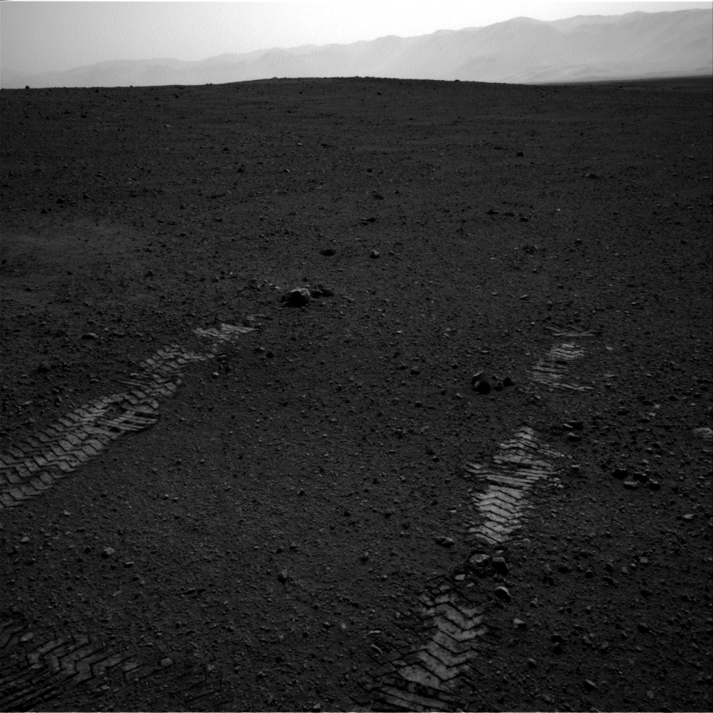
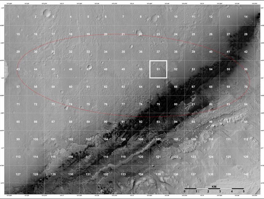
It's sol 22 as of this writing and Curiosity is heading east! It's destination: the Glenelg junction around 400m ahead where 3 types of rock units have occur together.You can see these 3 units in the image below converging on the red dot marking the junction.
The Neighbourhood. Curiosity's current destination, 'Glenelg' lies 400m to the east. (Commons)
The team played the music 'Hit the Road Jack' to mark the beginning of sol 22 and to mark this drive which is the third so far and the longest yet: 16m to be precise heading eastwards. The last two drives were all about testing the mobility system's performance.

Today's drive comes as yet another mission milestone. The rover has so far tested out quite a number of instruments including the chemcam (which shoots a high power laser to vaporise materials at a distance to measure the chemical composition. It's first 'victim' was a basaltic rock called 'coronation') and the DAN (Dynamic Albedo of Neutrons) which is a really handy tool to have because it allows the detection of water ice beneath  the surface. A version of it exists aboard the orbiting Mars Odyssey which has allowed mapping of the planet's hydrogen content beneath surface (hydrogen implies water H2O).
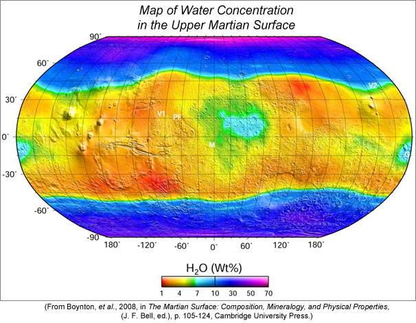
Derived H2O map from Mars Odyssey. DAN is set to find out if ice is underneath Gale.
Let's not forget the SAM (Sample Analysis at Mars) instrument which is by far I think the most impressive in the sense that they have actually managed to squeeze an instrument that would occupy a lab in to something about the size of your average microwave oven.
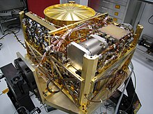
SAM on Earth. SAM sits inside Curiosity. (Commons)

SAM in essence IS an oven which can heat samples of soil and rock material to 1000 degrees Celsius and with the help of pipes, pumps and spectrometers of different kinds it reads out what compounds you're dealing with in your sample. Pretty slick! The number one question dealt with by this instrument is the question of Mars' organics (compounds containing carbon and hydrogen as the main constituent elements). Organics are important because they are usually associated with life. Whether Mars has any is an unanswered question. Past efforts in the Viking missions and the recent Phoenix mission have all come out zilch. A variety of reasons can be invoked to account for the absence of organics. The reason for the persistence is that even in the most barren terrestrial wastelands you still fins these compounds. Mars is pretty barren so if we DO find them, it would open up a whole Pandora's box of scientific inquiries especially with concern as to their origins.
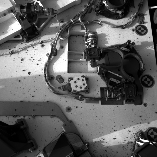
Sol 2 image of the rover deck. You can see the 2 tennis paddle shaped lids covering inlets into SAM right centre (NASA/JPL)
SAM recently opened it's lids to receive Martian air for it's first analysis as well as to evacuate any trace of terrestrial air still inside (it turned out that there was a lot of air still inside). A sample of earth's air was used for calibration purposes.

So we're off! Hopefully this is going to be one sweet ride!
It's now Sol (Martian day) 22 of the mission. Stay tuned.

Wednesday, August 29, 2012

Radio Curiosity broadcasts will.i.am's 'Reach for the Stars'

No there is no such station anywhere but Curiosity managed to broadcast back 2 sound clips from Mars. The first was returned on the Monday and consisted of a message from NASA's Administrator C.F. Bolden.
NASA's Admin. Bolden

In it he talked about the importance of Mars missions with a mention about human missions that will proceed on information returned by the robotic pioneers.

The second sound clip was returned on Tuesday and consisted of a  song by the musician will.i.am. The song's titled 'Reach for the Stars' and other than being cool (Curiosity just broadcast it. It never played as it hasn't any set of amps) the song's purpose was to instil inspiration in to the minds of young people to take up science and maths in their careers. That was thoughtful! You can read about and listen to the broadcast here. Look out for the Mohawk!

The adventure is just getting started folks! Stay tuned.
will.i.am (Commons)


Tuesday, August 28, 2012

Telephoto zoom magic

Layers at the Base of Mount Sharp

Follow the link above to see the kind of absolutely stunning results Curiosity's 100mm telephoto zoom cameras are producing! These images will be made available to James Cameron (director of 'Avatar' and 'Titanic') who is also part of the Mastcam science team.

The view looks to a distance of around 10km (more or less).

Monday, August 27, 2012

Tweening the descent footage


I found this footage made by a Dominic Muller who did exactly what I hoped someone would do.
Previous versions of Curiosity's descent video had a frame rate of 4fps (frames per second) which gave it kind of  rigid look. What Muller has done here is that by extrapolating the images between frames (called 'tweening') he has made the footage appear to proceed at a standard video speed of 25fps. It's still real time speed. In short its AWESOME!


Friday, August 24, 2012

Jim Bell talks about Bradbury

Here is Jim Bell's blog post on the Planetary Society's blog talking about Bradbury's contribution to space exploration and also how fitting it is to have Curiosity's landing site named after him.

Jim Bell is the principal investigator for the science imagers aboard the MER rovers Spirit and Opportunity (only Opportunity's functioning right now) and is currently the Society's president.

Wednesday, August 22, 2012

The Phantom rover of Bradbury Landing

Curiosity's landing site finally has a name; Bradbury Landing after the writer, Ray Bradbury.
Ray Bradbury (Photo by Alan Light)

Regardless of my naivete since I have yet to read any of his stories, needless to say his reputation preceded him and his passion for science and story writing made him a good guy in my books. His most famous and well known works include Fahrenheit 451 and The Martian Chronicles as well as a host of other equally good short stories.

Bradbury passed away this year on June 5th at the age of 91. He was known widely in the space community in America so he is greatly missed I'm sure. He even paid a visit at the Jet Propulsion Laboratories once and had a chance to drive the Mars Exploration Rovers at the time. So its no surprise that the mission team has decided on his name to commemorate Curiosity's landing spot. Bravo!

The rover has executed it's drive today perfectly (that was sol 16 I believe or August 22). The drive took 16minutes and placed the rover 6metres from its Bradbury Landing. So far so good!
Sol 16 navigation camera shot of Bradbury Landing and Curiosity's first set of tracks (NASA/JPL-Caltech)
This is an interesting picture because it looks as if the rover just appeared out of no where and started driving! I suppose that would make Curiosity the 'phantom of Bradbury Landing'!

UPDATE: here is a lovely video clip showing how exactly the rover drove today.

What It's Like to Land On Mars; Mind Blowing!

Broken instrument UPDATED

Dear readers, we might have a problem. According to this BBC news piece, MSL Curiosity has suffered its first broken instrument. Rover Environmental Monitoring Station (Rems), an instrument from Spain supposed to measure atmospheric conditions including ambient pressure, temperature, water vapour and so on has suffered damage which according to the mission's engineers may have been a result of the gravel that was thrown up during landing. If this is so then that must have been one heck of an impact because now the instrument readouts indicate exposed and/or severed wires leading out of the finger-like probes
The finger-like projections on the mast are part of REM (NASA/JPL-Caltech)

The damage will make it difficult to take wind speed and direction readings from a particular direction. I haven't a thought about how this instrument works but the ever-clever engineers say that it shouldn't be impossible to derive data and partially overcome this 'isolated disappointment'.

In other news, the rover has successfully unstowed and stowed its 2.1m robotic arm. That was on sol 14 I think and there are good pictures to show what it looked like below.


Arm deployed. You can see the instruments on the end of the arm and the drill pointed in our direction. (NASA/JPL-Caltech. Mosaic by Abraham Samma)
A twirl of the rear right wheel shows that the mobility system is okay. NASA says they will make a 1m or so drive forward followed by a 90 degree turn in place and then a reverse move. After that I suppose they will be off! It's going to be awesome!

UPDATE: I almost forgot to include this great link to the graphics shown at the recent NASA press briefing on the mission. Lots of good eye candy. Enjoy!

Monday, August 20, 2012

Planetary Society blog's Curiosity update

Check out the Planetary Society's Emily Lakdawalla's blog post (link below) for an absolutely fascinating account on what Curiosity's first destination and why the mission team is so interested in it.

Curiosity sol 11 update: Decision to drive to "the high thermal inertia unit" and what that means | The Planetary Society

Saturday, August 18, 2012

Scientific missions are hard!

Hello everybody! Just got back today. Boy is it good to be back home and in front of my laptop after a 1 week break. Well it wasn't exactly a break but a field work project that all undergraduate medical students have to go through. Ours focused on community health and my classmates and I spent 2 days of our 1 week leave to survey the Tanzanian coastal city of Tanga to see how children under five years fare with respect to their nutritional status i.e. how much of an adequate, balanced diet do they get and what forces influence the amount and/or type of food they get.

We're still making our final report but the situation can and needs to be improved. It's not Somalia that's for sure! But such projects tend to show us that when you plan a scientific endeavour or any research endeavour of any sort, it WILL tax your time, energy and sometimes patience. But in the end we explore to understand and act on the information we obtain from our various scientific missions to better our lives be it medical policies or Mars exploration. Curiosity and our field work may appear to be different in terms of monetary/resource priority but that may not be the case as I plan to illustrate in a future post. Stay tuned!

Curiosity has certainly been busy while I've been away. They plan to do a short drive later to test out their mobility following a successful updating of the rover's computer. Afterwards the rover's gigantic arm will be next in the checkout list I believe. We'll talk about all that later. But right now I really need to crash for the night.

Stay curious...

Saturday, August 11, 2012

Quad Yellowknife

In any problem it is always helpful to break down a problem in to its most basic components for easier analysis. In surveys they do just that, dividing an area in to sections (I'd tell you more but 'dammit Jim I'm a doctor not a surveyor!'). On Mars at Gale crater they're doing just that, dividing the area around the Curiosity in to 'quadrangles' or quads in short form to make it easier to survey the geological make up of the area in high resolution images from orbit. Take a look at the image below:
HiRISE image divided in to quads. Curiosity is in quad 51, Yellowknife. The landing ellipse is in red. (NASA/JPL/Univ. of Arizona)

What in Mars is Yellowknife? It's the largest city and capital of the North Territories in Canada. 
Ok... so why Yellowknife? Canada is home to the Canadian shield, the largest area of ancient rock that you will find in North America. These form the North American craton, simply put the core of ancient rock that formed North America when it was formed more than 3.9 billion years ago. A portion of these rocks bear the name 'Yellowknife' as well so the naming idea fits. After all, Curiosity is primarily a robotic geologist. 

Why is all this necessary? Curiosity is investigating its new home form a small perspective (i.e. its landing area). The team need to know the bigger picture so that they can plan ahead as the mission unfolds. Orbiters help in that category but they can't get at the actual rocks. You need someone on the surface doing that i.e. Curiosity. So these different missions are actually working together to help scientists on the home world figure out exactly what makes up Martian geology and it helps them to build up a rich and detailed portrait of Mars' past, present.

At the moment Curiosity has completed sol 4 activities and has now begun sol 5 which is reserved for a software upgrade to something more capable of handling surface operations. So I believe there won't be much to talk about over the weekend until the upgrade is complete. But please don't go away folks! This is just the beginning of a looooooooong and wild ride! 


Friday, August 10, 2012

Wow! UPDATED

And these are just thumbnail images!
Looking east. Gale in colour! (NASA/JPL)
These images were taken on the 9th this month and assembled into what you see. As you can see there are 2 grey areas (left and right of the rover) where the descent stage's rockets excavated the gravel and regolith.
In the distance at centre you can see the dark dunes hugging the slope of mount Sharp and further in the distance the rolling range of Gale crater's rim. The images were collected during late afternoon so they have been brightened a bit during processing. If you look at the dunes carefully you can see some other dunes of a different shade of colour. Why is this so? We'll just have to go there and see though those dunes are pretty menacing such that during cruise they did do some testing to see how the vehicle would perform on such terrain. We wouldn't want to get stuck now would we?

Initially I had wondered, considering how dirty the images looked due to the dust kicked up by the descent, how dirty was the rover itself. Turns out it's not as dirty as a coal miner but it is covered in gravel!
View of rover deck and surface sol 2. See the gravel on the deck? (Images by NASA/JPL; mosaic by me)


It's now sol 4, almost 6am at the landing site. These images were shot during sol 3.

Truly exquisite!

Wednesday, August 8, 2012

Tired but not out...

For some strange and unknown reason I feel exhausted today! Probably that pesky seminar paper summary I had to write on today. Any who, I am not leaving this blog's faithful readers without some reading material.

Yonder lies the Rim

Absolutely stunning stuff coming to you live from the surface of Mars!
This view looks to the north-east. You can clearly see the instruments on the arm (foreground) and the rim of Gale crater, (images by NASA/JPL. Stitching by A.B. Samma)
Stay tuned!

Curiosity's shadow; Sol 2

Sol 2 navcam raw view (NASA/JPL)
This view came from Curiosity's navigation cameras (these shoot only in black and white) used for mostly engineering purposes. You can clearly see her shadow and part of the arm to the bottom left. Go Curiosity!
According to the latest update, health are going well and the communication systems have been checked out (that was sol 1). Now that the mast has been deployed they are ready to start imaging the rover's surroundings with these cameras. In other news:

The team's plans for Curiosity checkout today included raising the rover's mast and continued testing of its high-gain antenna, whose pointing toward Earth will be adjusted on Sol 2. Science data were collected from Curiosity's Radiation Assessment Detector, and activities were performed with the Rover Environmental Monitoring Station instrument.

Tuesday, August 7, 2012

Curiosity's Descent


This video is what I've always wanted to see! It consists of 297 thumbnail images from the MARDI instrument and shows the view from the rover as it descended yesterday. It starts with the heat shield falling away and ends with a scene showing dust being blown by the descent stages's rockets (the 'jet-pack' that brought Curiosity down the last few hundred metres). These are only thumbnails, there are 660 high resolution colour images waiting to come down! Stay tuned.

MAHLI and MARDI Sol1

The Mars Hand Lens Imager or MAHLI, located on the robotic arm of Curiosity, has returned it's first image looking northwards and in the distance you can see the wall of the crater Gale.
(NASA/JPL/MSSS)
The image has been tilted to 30 degress to depict the horizon and sky correctly (that's the instrument's orientation right now). The image quality is bad because of the dust sitting on the lens cap. Once the cap is removed, MAHLI will be able to capture anything from the size of a penny to the scenery around the rover in colour!

MARDI, the descent camera has some wonderful thumbnail images and my favourite is the first showing the heat shield falling away.
Shields away! (NASA/JPL/MSSS)
 Brilliant!

Holy Smokes! If it ain't mount Sharp!

There it is guys! That's mount Sharp! That thing is 5.5km high! And we'll be heading there soon!
Mount Sharp ahoy (the big hill to the right)! Front hazcam sol 0 late afternoon looking eastwards (NASA/JPL)

A cartoon while we wait

This was totally my excuse for coming late to class today!

Monday, August 6, 2012

Getting our Bearings: Sol 0 (Landing day) review UPDATE 2


Ladies and gentlemen, Gale crater, Mars.
Rear hazcam image. Shown is part of the lens cover spring, left wheel and the nuclear power plant's cooling fin. Gale crater's rim is visible in the upper right corner in the distance. A spattering of dust can also be seen  (NASA).

Why silence?

Odyssey has set in the horizon from the rover's perspective so we'll have to wait a while for another orbital pass for more images.
I have to go to a medical class so see you all later.
Go here to see the 'raw' images transmitted by the rover so far.

We're on the surface! Images already coming in! Thumbnails for now, full sizes later.
We are now 3mins away from the first phase of EDL. Watch NASA TV now!

Virtual Landing Party for the Curiosity Lander


We're now 29,000km away from Mars. Cruise stage separation in under 2hrs.
Universe Today's Cain is LIVE

Sunday, August 5, 2012

Phoning Home: Communicating from Mars


This nifty little video was recommended at the pre-landing news briefing. It gives a good explanation on how we'll hear from the rover when it lands on August 6 (GMT)

Final Pre-landing news briefing

Just got off from watching the final news briefing on NASA TV before Curiosity hits the atmosphere in a little over 12hrs now.

Briefly now:

  • Martian weather is cooperating. There was a small dust storm south of Gale crater (the landing site) but it has already dissipated so no problem.
  • The engines of the descent stage have been warmed up for landing.
  • Course correction manoeuvre 6 (TCM-6) has been cancelled meaning Curiosity is still spot on target.
  • Curiosity has been deemed knowledgeable about its current trajectory so the engineers have deemed a position update unnecessary.
  • Images should be ready to go up in 4mins after landing.
  • Note: Mars Odyssey orbiter will be doing the job of relaying information from Curiosity back to Earth in real time. The other orbiters will not do real time relay.
  • It's now 3am at Curiosity's landing site, Gale crater so we have started Sol 0 or Martian day 0; landing day.

Landing day hotlinks

You'll notice a new button above beside the 'Home' button. It contains links to sites which will provide good quality coverage of the Curiosity landing when it happens. Timings are included. Enjoy!

Choosing a Landing site Part 3: Getting there


In this part we explore the details of the navigational issues of getting the rover to Mars and why we talk of landing ellipses and not just an X-ed target on the map.

Anything landing on Mars needs a target. Our target is Gale crater, 5.4°South by 137.8°East. Then we need to plan the flight path which should demand as little fuel as possible to help reduce costs. Mars flights usually proceed every 2.5 years when Mars and Earth are closest. But we don’t just go in a straight line to get there. Why? Because it would be gravitationally expensive (moving away from the sun, you have to use energy to overcome its gravitational pull) and even if you go that way by the time you reach the planet it would have already have moved out of the way along its orbit. So we use a route called a Hohmann transfer orbit.

Ride with Curiosity.

NASA has a neat little tool called 'Eyes on the Solar System' which generates computer simulations of the solar system and let's one visualise positions of the space crafts 'live'. Here you can literally ride with a realistic virtual model of Curiosity and see how things progress live as they happen! Now that's cool.

18hrs to go people! Stay on-line and stay curious for the coming event.

Saturday, August 4, 2012

When London 2012 and Curiosity mix.

Quite hilarious! See here.

Martian Smackdown Countdown Clock

Choosing a Landing site Part 2: Choose only one...


In part 1 I talked broadly about the history of choosing landing sites on Mars and what factors influence the selection process regardless of spacecraft type. I encourage you to read it all here.

In part 2 of our examination of the landing site selection process of the Curiosity mission to Mars, we focus on the scientific efforts that went in to trimming the list of candidates for examination by the new rover mission to just one choice that would just about cover everyone’s experiments’ goals.

Friday, August 3, 2012

Join Universe Today’s Live Webcast of the Curiosity Rover Landing

I have a confession; I love the way Google has revolutionised my life! :-)
Second confession; I have never attended a Google+ hangout. If you haven't too then this a golden opportunity to check out one of my favourite websites, Universe Today's Live webcast of Curiosity landing on August 6 UTC. Details are all below, just follow the link. Enjoy and see you there I hope. And hopefully we'll have a live spacecraft to talk about all week long!

Join Universe Today’s Live Webcast of the Curiosity Rover Landing

Thursday, August 2, 2012

Curiosity's science instruments and how they work by The Planetary Society

The Planetary Society in Pasadena, CA, USA has published great videos that summarize the instruments that Curiosity will be using on the surface of Mars. Note that in the first video segment about cameras they note 16 individual cameras. There are actually 17, including the Mars Descent Imager (MARDI) that we talked about in this post. There will be 3 videos with last one made specially for kids so make sure you share with your kids if you want to instil science wonder in them!
Check out the videos in the link below:
Videos: Where are Curiosity's science instruments and how do they work? | The Planetary Society

4 days left! The suspense is murder!

Wednesday, August 1, 2012

Choosing Landing Sites Part 1: Opening new avenues


Previous missions' landing sites (NASA/JPL)


As I promised I will be concentrating on the details of Curiosity’s landing site for the remainder of cruise time. As of this post the space craft has entered approach phase and is now accessing autonomous protocols in its onboard computer that will take it through the EDL phase (entry, descent and landing) in the coming days.

The process of choosing landing sites is quite a long one let alone describing the landing site itself. Therefore I’ll deal with this topic by breaking down it into 3 posts to keep things short. In this part I’ll talk about the process of choosing a landing site, its history and what factors influence the decisions of scientists and engineers and policy makers involved in this mission one way or another.