Monday, October 27, 2014

Back to the drawing board

Emily from the planetary society brings us an incredible summary of the latest in scientific findings from the Curiosity mission as presented at the recent Geological society of America's annual conference.

The results are astounding as they are intriguing. Mars' geological history according, atleast to the MAHLI science team, appears to be resemble less like Earth, or the present Earth that we know of anyway. Read on here.

Stay curious!

Sol 790 Navcam image looking east across light-toned sedimentary
rocks and buttes. There's Mount Sharp to the right.
Map the view here. See the latest images here.

Friday, October 17, 2014

Full Disk Galore

While not the most scientifically valuable images, these full disk colour views of Mars from India's Mangalyaan Mars orbiter help to highlight the beauty of the Red planet and helps us to appreciate its harshness and its bleakness and contrast it with our homeworld's lushness and vitality. Note you can see a dust storm brewing in the Northern regions in the image. This is typical for this time of the Martian year as the planet transitions from Northern autumn to winter solstice which will begin next year in June. Due to Mars' eccentric orbit (eccentricity is the degree of deviation from a perfect circle), it tends to get warmer during this time of the year (Northern autumn or southern spring) because the planet comes closer to the sun and consequently experiences thermal instabilities in the atmosphere that give rise to storms.


Here is a stop animation showing Mars' largest moon Phobos captured as a black little speck moving over the Martian disk. Awesome!

Thursday, September 25, 2014

Mangalyaan and Maven arrive at Mars

There is quite a crowd over the red planet right now. More diverse now that India's Mangalyaan  orbiter has arrived.

I'll just use this post to dump links that might interest you concerning both these missions. First off, Maven, a mission dedicated to studying Mars' atmosphere, in particular, the volatiles and other important trace gases that exist in the Martian air like argon, oxygen, hydrogen and methane, the one gas that may signify ongoing biological activity. Checkout the mission's homepage over at NASA as well as the lab for atmospheric and space physics' homepage. First images from the spacecraft's ultraviolet spectrograph and imager with a description can be found here.

Mangalyaan made many Indians proud yesterday when it succesfully slipped into an elliptical orbit around Mars. They are only the fourth nation or geo-bloc to do so. Below are images taken by the spacecraft showing I think a view of the ancient cratered highlands south of Syrtis major which is the black feature near the bottom. Checkout the Indian space research organisation's homepage for updates (though it seems they make more use of their facebook page for posting updates).

Credit: ISRO
Here is a map showing context (also from the facebook page which is teeming with enthusiasts right now helping to make sense of the first images). Note for both images north is down.


Here is another image showing a limbic view and the dusty atmosphere.
Credit: ISRO
The last image was taken at an altitude of 8449 km according to the mission's facebook page so we should soon get a good full disc view when the spacecraft reaches apopsis at 77000 km above the planet. Do keep on reading over at Emily's blog

Thursday, September 11, 2014

Sol 747: Arrival at Base camp

Hooray! After 2 long years of seemingly perpetual driving (the wheels' state are a testament to that), Curiosity has finally arrived at the base of Mount Sharp.

According to the newest press release from NASA JPL:

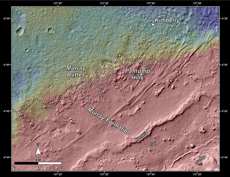
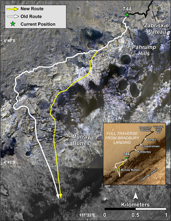
Curiosity's trek up the mountain will begin with an examination of the mountain's lower slopes. The rover is starting this process at an entry point near an outcrop called Pahrump Hills, rather than continuing on to the previously-planned, further entry point known as Murray Buttes. Both entry points lay along a boundary where the southern base layer of the mountain meets crater-floor deposits washed down from the crater's northern rim.
Here are two maps to give you some context; the first is a topographical map showing the nature of the terrain and the contact marked with a dashed line representing two different geological regions. The second is a false colour image from the Mars Reconnaissance Orbiter showing the old and newly planned routes as well as the contact between the Murray formation of rocks (named after the nearby buttes) which are lighter toned and the darker coloured plains. You may also notice in the first map that the Murray formation has scarcely any craters and looks smoother compared to the older plains. We are definitely not in Kansas anymore!

The rover has already had a go at the Murray rock formation:

Curiosity made its first close-up study last month of two Murray formation outcrops, both revealing notable differences from the terrain explored by Curiosity during the past year. The first outcrop, called Bonanza King, proved too unstable for drilling, but was examined by the rover's instruments and determined to have high silicon content. A second outcrop, examined with the rover's telephoto Mast Camera, revealed a fine-grained, platy surface laced with sulfate-filled veins.
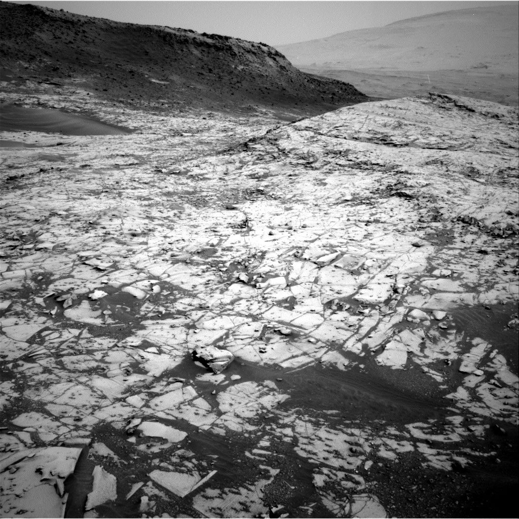
And lets not forget the view, which is just spectacular! Buttes and layers as far as the rover can see.
A view of the "Amargosa valley" which runs through "Pahrump Hills" seen above the scale (NASA/JPL)
Hopefully the mission will now deliver the much wanted science which will definitely help its standing amongst senior scientists who recently labelled it last in a review of NASA planetary missions. You can read all about that here.